

Mount Royal is well known for its aviation programs, offering both a diploma and a degree, but students and professors are flying in another way: using drones.
Drones or uncrewed aerial vehicles (UAVs) have been around since the 1800s, with the Austrian Navy using 200 incendiary balloons in an effort to capture Venice in 1849. The technology looks a lot different today than it did back then, however. Hobby and commercial drones have skyrocketed in popularity in recent years and are being used in a number of different ways.
Reaching new heights in wildfire research
Here on campus, four drones are available and in use within the Department of Earth and Environmental Sciences. Each UAV is equipped with different technology that serves a different purpose across a variety of disciplines.
"The main reason we got these drones is because they have a utilitarian purpose. You can plug and play with different sensors and tools on them," says Shane Steininger, environmental science technologist.
"Originally we got them for ecology-based purposes. For example, we have a multispectral camera that can do chlorophyll mapping," he explains, adding that now the drones are equipped with thermal imaging that helps with forensic chemistry and wildfire investigations.
One of the drones has also been equipped with a light detection and ranging camera (LiDAR), which can be used for geospatial-based research. It can also be really helpful in wildfire investigations as it can capture the density and type of vegetation from above.
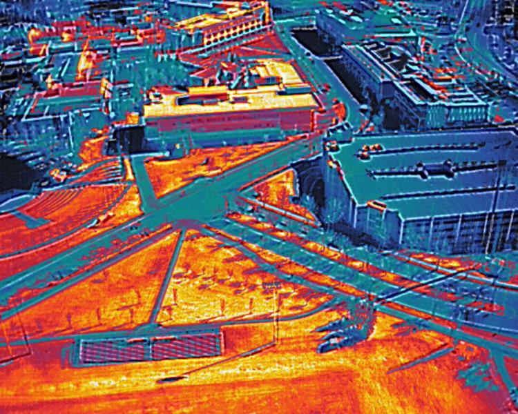
A thermal image of MRU's campus as captured by the Department of Earth and Environmental Sciences drone above the soccer field.
Dr. Gwen O'Sullivan, PhD, vice-dean of research and scholarship within the Faculty of Science and Technology credits Brian Sevick, who was chair of the Department of Earth and Environmental Sciences at the time the drones were purchased, for his understanding of the technology and how drones could be adopted into a teaching and learning setting.
O'Sullivan's use for drones is related to wildfire and forensic arson investigations, however, recently she has been researching wildfire smoke.
"We're really interested in learning about how smoke evolves and how it can impact the health of an urban environment," she says.
Wildfire smoke monitoring can be challenging from the ground, according to O'Sullivan, but the use of drones allows for better information gathering in a more safe manner. The addition of low-cost sensors and sampling tools on the UAVs allows O'Sullivan and her team to collect samples from different elevations and locations within the city.
Historically, O'Sullivan says wildfire smoke samples have been collected using balloons and small planes, but both of those monitoring methods come with barriers. For starters, they are both weather dependent and the trajectory of a balloon is dictated by the wind, making them less versatile. Planes can go high up in the atmosphere, but not into smaller urban areas, whereas a drone can follow a smoke plume from its source and as it moves through communities.
"With drones we can get a much better idea of a vertical and horizontal understanding of the atmosphere on a smaller scale," O'Sullivan says, who also points out that the drones don't admit exhaust so there is no risk of cross contamination.
"These drones are really versatile and allow us to map an area in an urban environment, which is not accessible to using other tools."
O'Sullivan highlights the importance of connecting the advances in drone technology with the advances in sampling technology. "The combination of those two pieces really allows us to increase the flexibility in the sampling environment."
Both O'Sullivan and Steininger see drones becoming more and more prominent in both research and classroom work in the coming months and years, and in more and more complicated scenarios. UAV technology advances at an almost daily rate, according to O'Sullivan. "Battery sizes are getting smaller, we can fly longer with heavier payloads and the maneuverability of them is unmatched."
Steininger adds that drones are becoming more accessible because prices are coming down too, meaning the future will see even more applications for this technology. "They allow researchers and students to get more specific and relevant data," he says, pointing out that mapping data, for example, is available online, but there are gaps. "So having the ability for researchers and professors to gather their own mapping data in a smaller, more controlled environment is huge."
Drone piloting is no small feat. There are rigorous regulations outlined by Transport Canada as well as provincial and municipal rules around flying drones. In order to be able to fly MRU's drone fleet, Steininger had to take part in a number of training sessions to become a certified pilot. That training culminated with a test similar to a road driving test where he had to fly a drone alongside a supervisor.
"Especially working in an urban environment, having a level of education and responsibility before sending them up is definitely a must."
He says a lot of work, maybe even the majority of it when flying a drone, happens before a flight. Flight planning is key, says Steininger, adding that he must be hyper vigilant of the environment the drone is going to be flying in.
New business takes flight
How did MRU business student and entrepreneur Charter Beselt go from the football field to helping farmers with their fields? It might seem like an unlikely path, but it's a unique one that started in Saskatchewan while Beselt was playing football with the University of Regina.
Beselt says being in Saskatchewan, he was surrounded by farmers and began to realize just how huge the agriculture industry is and how much money and time farmers spend tending to their crops and fields. That realization led to him brainstorming with his roommate Garret on how to make the industry more efficient. Garret's dad, a farmer, had recently mentioned to the pair how he had spent days trying to repair a combine after it had been damaged by a rock and had missed an important seeding window as a result.
"He had a hobby drone that we would fly on the weekend and we decided to see if there was a way to combine the two and it turns out, there was a hole in the market," Beselt says, who ended up transferring to Mount Royal in his third year.
Upon coming to MRU, Beselt entered the Institute for Innovation and Entrepreneurship's LaunchPad program, which sees students work with coaches on their business idea over an eight-week period. The program culminates in a Dragons' Den-style pitching competition where up to $70,000 in prizes can be won. Beselt walked away from the 2024 JMH LaunchPad Competition with $30,000 in funding to help bolster his business.
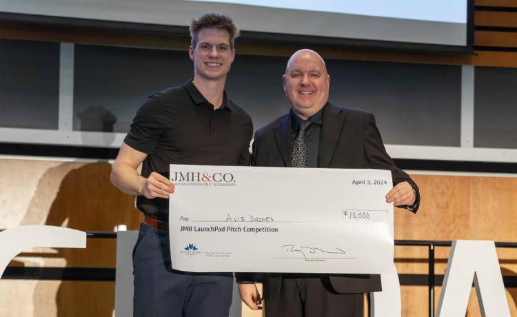
Charter Beselt, left, from AVIS Drone Solutions won the $10,000 JMH & Co. Award, $5,000 LaunchPad Alumni Award and $15,000 Catch Digital Award at the 2024 JMH LaunchPad Pitch Competition.
Through the program, he was able to build on the idea of using drones in agriculture to launch his company AVIS Drone Solutions. The company uses technology from Threshold UAV, which allows multiple drones to fly at once by one person, which reduces both labour costs and operation time.
"That makes mapping a two hundred-acre field extremely efficient," Beselt says, who adds that the primary focus of Avis Drone Solutions is to help farmers map their crop fields for rocks. "It mitigates the risk of tractors and combines striking a rock during harvest season."
A rock strike might not sound serious for those not familiar with agriculture, but Beselt says they can be devastating. "In a drought a rock strike can start a fire. It can also damage the blade of a combine, which takes days to replace, not to mention the cost of that repair," he explains.
With AVIS' services, farmers can get a detailed high-resolution map of where rocks are and the fastest route to pick them. Beselt says 160 acres can be rock mapped by one person in as little as 30 minutes.
Beyond rock mapping, AVIS Drone Solutions can help with crop health and yield analysis, crop monitoring and weed detection. Outside of agriculture, AVIS Drone Solutions has been doing mapping and other topographic surveying in a variety of industries as well as drone videography for commercial purposes.
Beselt says it is almost overwhelming to learn about all of the applications for drones beyond agriculture. Like O'Sullivan and Steininger, Beselt has been amazed at how quickly drone technology is evolving. "Even the drones we're seeing coming out now are so much more advanced than what we saw coming out just a few months ago."
Beselt is working on a number of test flights and client flights over the summer before he returns to campus for his final year of his Bachelor of Business Administration.
