
Grade 10 and 11 students from Saugeen District Secondary School got a glance into the world of mapping and apps at the first student GIS Day in Saugeen Shores on November 14. Approximately 40 students attended the 3-hour event where they took part in 4 interactive workshops focusing on mobile GIS, apps, story maps, 3D mapping and solving municipal problems with GIS.
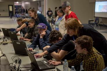
SDSS Students took part in interactive workshops where they got hands-on experience with GIS technology.
The goal of the event was to introduce high school students to GIS (Geographic Information Systems) and the cool' ways it can be used. The workshops allowed students to explore the high-level problem-solving solutions that use GIS data. As GIS technology becomes an integral part of many industries, it is a promising (though somewhat unknown) career path with significant employment opportunities now and in the future.
"Most people see GIS as mapping - which it is in its most basic form - but it's so much more powerful than that," said Laura Kranenburg, Supervisor, Asset Management & GIS. "GIS is basically taking data and making it spatial - giving it a location on the earth and using that spatial ability to analyse data, solve problems, improve workflows and make it relatable for the end user. You would be hard-pressed to find an industry in the world today that isn't using GIS in some way."
The event was hosted by the Town of Saugeen Shores in collaboration with Bruce County and municipal GIS professionals across the county with hopes that it will become an annual workshop.
For more information
600 Tomlinson Drive, Box 820
Port Elgin, Ontario
Canada N0H 2C0
www.saugeenshores.ca