The beaver is a well-known symbol associated with Canada. But in Alberta, beavers are not always looked upon favourably.
Historically, tensions between beavers, farmers and ranchers have been high, as beavers can fell many trees and their dam-building can cause fields to flood, damaging crops and grazing areas. That's why researchers from the University of Saskatchewan have been using a field station run by the University of Calgary's Biogeoscience Insititute to deepen their understanding of how beavers interact with their environments. The researchers are exploring the impacts of beavers and their structures on hydrology and ecosystem health within the Sibbald Valley in Kananaskis Country.
The USask team has been studying beavers in this area for more than 10 years, using the Barrier Lake Field Station about 60 kilometres west of Calgary almost every summer to complete their field work.
Environmental impact as it happens
Being able to monitor changes to a site in real-time is vital. For example, this year there was a major dam breach following a heavy rainstorm that significantly changed the structure of the beaver ponds. Researchers could observe the landscape changes as they unfolded rather than piecing together what happened from datasets later.
Another challenge that arose before research could even begin this year was a human-beaver conflict. At the main research site near Sibbald Lake, beavers' tree-felling caused flooding for a nearby camp. Students from the USask lab worked in the spring to build and repair fencing, thereby deterring the beavers from the camp area, constructing a more harmonious relationship between beavers, camp-goers and researchers.
Emily Ireland, a master's student in USask's Ecohydrology lab under Dr. Cherie Westbrook, was based at Barrier Lake this past summer. Her research interest is mapping how water moves through a series of beaver ponds, and how that hydrology is impacted by forestry operations on slopes above the ponds.
One part of her project involves looking at input and output sources for water entering the peatland area. Using small wells installed at various springs and streams throughout the area, Ireland takes measurements of groundwater and surface water depth and water pressure. By correlating the pressure measured by the data-loggers in the wells with the atmospheric pressure, she converts the pressure value into a measurement of water discharged at the sources. The conductivity of the water is also tested, as conductivity can be used to determine the amount of groundwater entering the system.

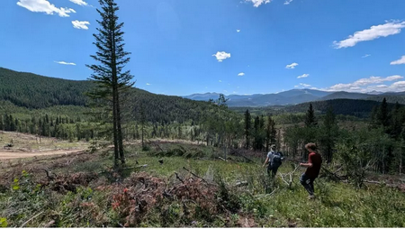
Emily and Davis Ireland hike through a clear-cut area above the Sibbald beaver ponds. Photo Credit: Briana Van Den Bussche
A second part of Ireland's project involves aerial drone photography. After gathering a series of images of the pond complex, she applies mathematical models to determine the volume of water in the ponds. This data is one more piece of the puzzle when trying to calculate the total amount of water entering and exiting the system. These values, along with the data collected at the wells and streams, provide a more complete picture of all water input including groundwater, surface water and precipitation.
Ireland is also interested in how clear-cut logging on the slopes above the pond complex might alter the volume and speed of water entering the ponds. This work includes monitoring soil moisture levels on nearby slopes that remain treed and those that have been clear-cut.
Following the field season, Ireland began analyzing her data back home at USask to get final numbers for the input and output of water in the system. She hopes to be able to use the data to build a complete model of the hydrology of the peatlands. This model will be used to better understand how beaver ponds and forestry are changing the speed and direction of water moving through the area.
Research assistants Davis Ireland and Julia Howell Bourner spent the summer assisting Emily Ireland and other graduate students with their data collection, while also working on undergraduate projects of their own.
Davis Ireland's project looks at water retention in different soils, comparing the soil from current beaver ponds to soils in drained pond areas, as well as to forest areas nearby that have and have not been logged.
Howell Bourner is interested in the shape of the individual ponds. Using a differential GPS, a special kind of GPS accurate to within 25 centimetres, she maps the edges of all the ponds in the complex. She hopes to use the data to create a 3D scale model of the area.
This summer's projects, as well as past data collected by students in the Ecohydrology Lab, are currently being used to build a citizen-science project called Castor Tracker. The project will help researchers study how beavers are moving on the landscape at all times of year and give the public a chance to contribute to this important study.
Educators at UCalgary's Biogeoscience Institute have been working with Westbrook, as well as the Howl Experience an experiential education program for youth to design a program for high school students based around the Castor Tracker and ecosystems in the Sibbald Valley. The program aims to have students explore different ways of learning in and with the land, including western science methods and Indigenous Ways of Knowing.


